The Irish Aviation Authority and Motorsport Ireland have issued the below statement – it can be download in full below – including maps – short excerpt here:
These Temporary Restricted Areas (TRAs) are designated by the Irish Aviation Authority at the request of an Garda Síochána in the interest of public safety and are applicable to all aircraft types including helicopters and unmanned aircraft systems (drones).
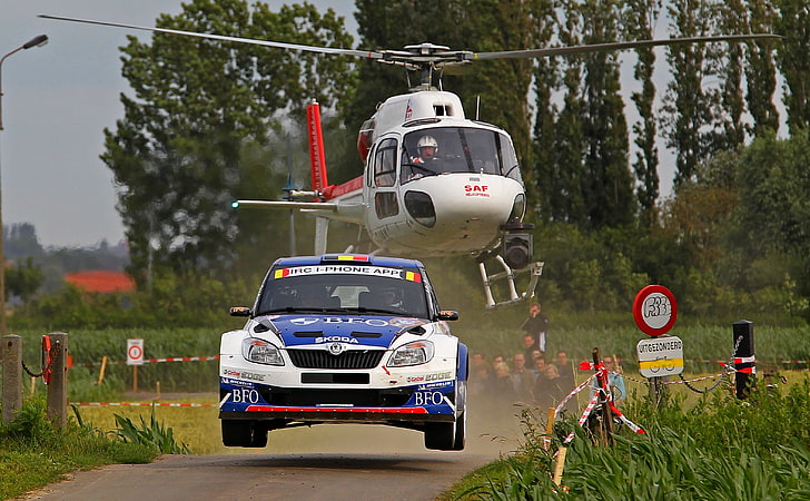
The purpose of the TRAs is to allow the Donegal Rally event to take place while safeguarding the safety of competitors and spectators from distraction or interference from aviation activities in the
vicinity of [the rally]
Flight Restrictions in the vicinity of Mamore Gap, Coolcross, Carndonagh, Malin Head,
Lough Keel, High Glen, Letterkenny, Knockalla, Atlantic Drive, Fanad Head
and Gartan, County Donegal
Friday 21st June to Sunday 23rd June, 2024
The Irish Aviation Authority in pursuance of Articles 7 & 10 of the Irish Aviation Authority (Rules of
the Air) Order, 2019 (S.I. No. 266 of 2019) and in accordance with Commission Implementing
Regulation (EU) No. 923/2012, SERA.3145 (Prohibited Areas and Restricted Areas), hereby directs as
follows:-
Temporary restrictions (Temporary Restricted Areas) on the flying of aircraft and rockets as defined in
S.I. No. 25 of 2023, including Unmanned Aircraft Systems (UAS) as defined in S.I. No. 24 of 2023
and Commission Implementing Regulation (EU) 2019/947, shall apply in the vicinity of County
Donegal in the airspace contained within the under mentioned:
TRA 1 (Mamore Gap) Lateral Limits: 55° 17′ 30.39″N, 007° 30′ 07.99″W
55° 17′ 10.59″N, 007° 27′ 27.84″W
55° 13′ 06.69″N, 007° 28′ 37.62″W
55° 11′ 23.72″N, 007° 32′ 02.45″W
55° 12′ 35.23″N, 007° 33′ 59.12″W
TRA 2 (Coolcross) Lateral Limits: 55° 16′ 14.28″N, 007° 17′ 54.60″W
55° 13′ 23.98″N, 007° 18′ 25.26″W
55° 14′ 38.75″N, 007° 24′ 56.30″W
55° 16′ 48.97″N, 007° 23′ 10.77″W
TRA 3 (Malin Head) Lateral Limits: 55° 22′ 17.96″N, 007° 17′ 37.09″W
55° 19′ 00.46″N, 007° 18′ 00.11″W
55° 19′ 12.40″N, 007° 21′ 45.71″W
55° 21′ 06.19″N, 007° 21′ 46.72″W
55° 22′ 16.65″N, 007° 24′ 59.77″W
55° 23′ 21.64″N, 007° 22′ 21.97″W
TRA 4 (Carndonagh) Lateral Limits: A circle radius of 0.5NM centred on:
55° 15′ 15.56″N, 007° 15′ 16.32″W
TRA 5 (Lough Keel) Lateral Limits: A circle radius of 2NM centred on:
55° 03′ 16.53″N, 007° 46′ 53.40″W
TRA 6 (High Glen) Lateral Limits: 55° 08′ 24.54″N, 007° 48′ 37.11″W
55° 08′ 05.94″N, 007° 42′ 16.60″W
55° 06′ 53.21″N, 007° 42′ 01.29″W
55° 04′ 33.38″N, 007° 52′ 59.72″W
55° 05′ 23.82″N, 007° 53′ 34.69″W
FLIGHT
RESTRICTION
NOTICE
v1.0
IRISH AVIATION AUTHORITY Page 2 of 2
TRA 7 (Knockalla) Lateral limits: 55° 11′ 54.82″N, 007° 37′ 37.04″W
55° 11′ 41.26″N, 007° 34′ 36.68″W
55° 08′ 11.67″N, 007° 30′ 37.59″W
55° 04′ 07.19″N, 007° 35′ 31.52″W
55° 03′ 09.96″N, 007° 39′ 12.57″W
55° 07′ 09.12″N, 007° 41′ 12.64″W
TRA 8 (Letterkenny) Lateral limits: A circle radius of 1.5NM centred on:
54° 57′ 18.81″N, 007° 43′ 26.94″W
TRA 9 (Atlantic Drive) Lateral limits: A circle radius of 1.6NM centred on:
55° 12′ 35.06″N 007° 50′ 14.14″W
TRA 10 (Fanad Head) Lateral limits: 55° 16′ 53.68″N, 007° 37′ 38.60″W
55° 12′ 06.29″N, 007° 34′ 36.98″W
55° 11′ 58.52″N, 007° 37′ 18.75″W
55° 13′ 34.38″N, 007° 45′ 11.35″W
55° 15′ 34.05″N, 007° 45′ 11.17″W
TRA 11 (Gartan) Lateral limits: 55° 03′ 18.05″N, 007° 51′ 17.64″W
55° 02′ 27.10″N, 007° 45′ 37.93″W
54° 58′ 46.91″N, 007° 52′ 48.70″W
55° 00′ 33.59″N, 007° 56′ 28.60″W
Vertical Limits TRA 1 – 11: SFC to 2000FT AMSL
Duration TRA 1 – 4: The period of the restriction shall be from 0600hrs UTC to 2100hrs UTC on
Friday June 21st
, 2024.
Duration TRA 5 – 8: The period of the restriction shall be from 0600hrs UTC to 2100hrs UTC on
Saturday June 22nd, 2024.
Duration TRA 8 – 11: The period of the restriction shall be from 0600hrs UTC to 2100hrs UTC on
Sunday June 23rd, 2024.
These Temporary Restricted Areas (TRAs) are designated by the Irish Aviation Authority at the
request of an Garda Síochána in the interest of public safety and are applicable to all aircraft types
including helicopters and unmanned aircraft systems (drones).
The purpose of the TRAs is to allow the Donegal Rally event to take place while safeguarding the
safety of competitors and spectators from distraction or interference from aviation activities in the
vicinity of Mamore Gap, Coolcross, Carndonagh, Malin Head, Lough Keel, High Glen, Letterkenny,
Knockalla, Atlantic Drive, Fanad Head and Gartan, County Donegal during the periods cited.
The airspace contained within the TRAs shall be classified as ICAO Class G.
Point of contact during activation is Letterkenny Garda Station +353 (0) 74 91 67 100.
Unmanned Aircraft Systems operated in breach of TRA restrictions may be subject to seizure by An
Garda Síochána as evidence for potential prosecution and in the interest of Aviation Safety.
Any exemptions, alleviations or permissions, granted to civil general air traffic by the Authority, are
not valid within this Temporary Restricted Areas during the period cited.
State aircraft, aircraft of the Irish Coastguard Service and HEMS Aircraft Operators employed on an
operational mission shall be exempt from the restriction including Unmanned Aircraft Systems
authorised by the controlling authority and State Unmanned Aircraft Systems.
NOTAMs will be issued in due course to notify of the activation of the TRAs.
Any queries may be addressed to the Irish Aviation Authority by email at fod@iaa.ie
Just as newspapers and magazines are paid for, digital editorial content will also have to be paid for.
Please subscribe and help us keep this machine running!
It’s only €50 per year – subscribe now
Subscribe to get access
Read more of this content when you subscribe today.
